Information and Service Signs
Most of these signs tell you things rather than order you. A common trick is to dress one up as a rule, so remember that a blue rectangle or square in these two families informs or advises.
Information signs (family 6)
Section titled “Information signs (family 6)”Most are blue squares or rectangles. Sign 6.16 is white, and sign 6.19.1 is yellow.
| Sign | No. | Name | Meaning |
|---|---|---|---|
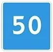 |
6.2 | Recommended speed | The preferred speed for this stretch. Advice only |
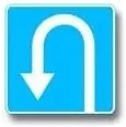 |
6.3.1 | Place for turning | A place set aside for a U-turn. Left turns are prohibited here |
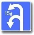 |
6.3.2 | Turning zone | The figure inside gives the length of the zone for turning |
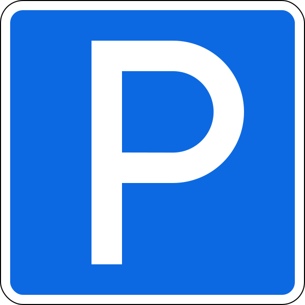 |
6.4 | Parking place | Parking is provided here |
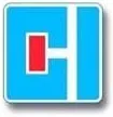 |
6.8.1 | Dead end | No through passage. Entry isn’t prohibited |
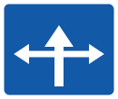 |
6.9 | Advance direction indicator | Route and direction information |
 |
6.14.2 | Route number | Gives a route number |
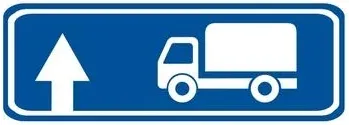 |
6.15.1 | Direction of movement for lorries | Recommended way for trucks, straight on |
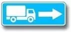 |
6.15.2 | Direction of movement for lorries | The same, to the right |
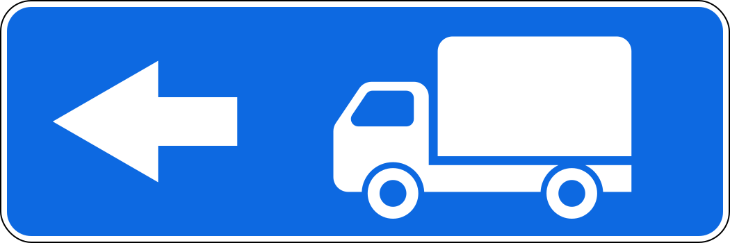 |
6.15.3 | Direction of movement for lorries | The same, to the left |
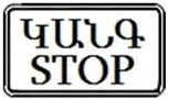 |
6.16 | Stop line | Where to stop on a prohibiting signal |
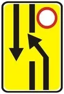 |
6.19.1 | Advance indicator of changing lanes to another carriageway | The way round a closed carriageway on a road with a dividing strip |
Common trap: The number 50 on a blue square is a suggestion. It isn’t a maximum (that is the red ring 3.24) and it isn’t a minimum (that is the blue disc 4.6). This stays true with plate 8.16 “Wet surface” below it: “On a wet road surface it is recommended”, never “permitted”.
Next to a warning sign, sign 6.2 lasts for the length of that dangerous stretch.
Sign 6.15 is advice too. It suggests a way for trucks, tractors and self-propelled machines when their movement in some direction at the intersection is prohibited. It closes nothing. Only the prohibitory sign does, and only in its own direction.
Sign 6.19.1 sends you across to the other carriageway, because yours is closed ahead. It isn’t an indicator for bypassing a local obstacle. When you see it, you can’t continue straight: move to the oncoming carriageway, as it shows. Signs 6.19.1 and 6.19.2 also show the way back.
Service signs (family 7)
Section titled “Service signs (family 7)”Look for a blue rectangle with a white square inside. They point you to something useful.
| Sign | No. | Name | Meaning |
|---|---|---|---|
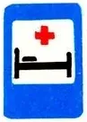 |
7.2 | Hospital | A bed with a cross |
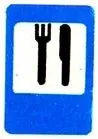 |
7.7 | Food point | Knife and fork |
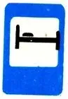 |
7.9 | Hotel or motel | A bed without a cross |
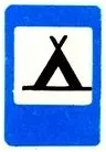 |
7.10 | Camping | A tent |
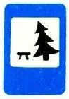 |
7.11 | Rest area | A table and a tree |
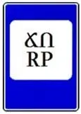 |
7.12 | Traffic police patrol post | Only tells you a post is there |
Try it yourself
Section titled “Try it yourself”In which case is the length of the zone for the U-turn shown?
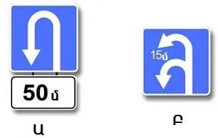
Only Բ (B). A figure inside the sign, 6.3.2, is the length of the zone. The separate plate in Ա (A) is 8.1.1: the distance from the sign to the place, 50 m.
You drive the truck. Sign 3.4 stands on the road straight ahead, and the blue sign for trucks points right.
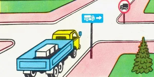
Where may you go? Right, left, or the opposite direction. Only straight ahead is banned. The blue sign recommends. It doesn’t compel.
This sign stands by the road through the forest.
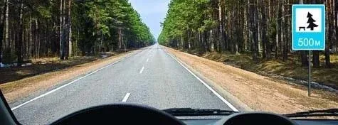
What does it say? There is a rest area after 500 m. The plate gives the distance to it, not the length of a stretch. It isn’t a warning about a fallen tree, because it is blue and not a triangle.
Key points
Section titled “Key points”- Blue squares and rectangles here inform or advise.
- 6.2 only recommends a speed, even with a plate.
- 6.3.1 marks a place for a U-turn, and left turns are prohibited there. 6.3.2 shows the zone’s length inside the sign.
- 6.8.1 means no way through, but you may enter.
- 6.15 recommends a route for trucks and bans nothing.
- 6.19.1 is the yellow sign that moves you to the other carriageway.
- Service signs: 7.2 is a bed with a cross, 7.9 a bed without one.
Practice questions
Section titled “Practice questions”Question 16. This sign is called
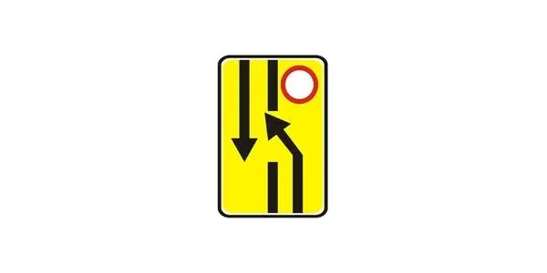
- Advance indicator of bypassing an obstacle.
- Advance indicator of changing lanes to another carriageway.
- Advance indicator of moving out into the oncoming traffic lane.
Show answer
Correct: 2. Advance indicator of changing lanes to another carriageway.
The picture shows a yellow advance sign whose arrows guide traffic away from a carriageway closed ahead - marked by the red prohibitory disc - and across to the other carriageway. That is sign 6.19.1, 6.19.2 “Advance indicator of changing lanes to another carriageway”, which the Rules define as the direction to be taken to bypass a closed section of one carriageway on a road with a dividing strip, or to return to the right-hand carriageway. It is not an “Advance indicator of bypassing an obstacle”: a local obstacle is marked by plate 8.22 “Obstacle” used with signs 4.2.1 to 4.2.3, whereas here the entire carriageway is closed. Nor is it an advance indicator of moving out into the oncoming lane - 6.19 directs traffic onto a separate carriageway of a divided road, not into the oncoming flow, and no sign with that meaning exists.
Question 25. This road sign shows
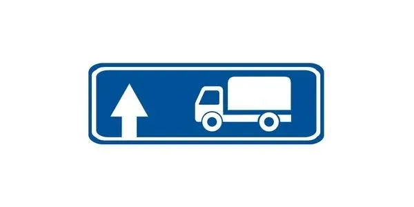
- A road with one-way traffic on which only the movement of trucks is permitted.
- The lane intended only for the movement of trucks.
- The recommended direction of movement for trucks.
Show answer
Correct: 3. The recommended direction of movement for trucks.
The picture shows a blue information sign with an arrow and a lorry on it: signs 6.15.1 to 6.15.3 “Direction of movement for lorries”, which the Rules define as the RECOMMENDED direction of travel for lorries, tractors and self-propelled machines where their movement in some direction at the intersection is prohibited. “The recommended direction of movement for trucks.” is therefore correct. It is not a one-way road on which only lorries may travel: one-way traffic is established by signs 5.5 and 5.7, and this blue sign neither makes the road one-way nor bars other traffic. Nor is it a lane reserved for lorries - a reserved lane is shown by the lane signs, while 6.15 points out a recommended direction at an intersection.
Question 26. Which of the signs is called “Hotel” or “Motel”?
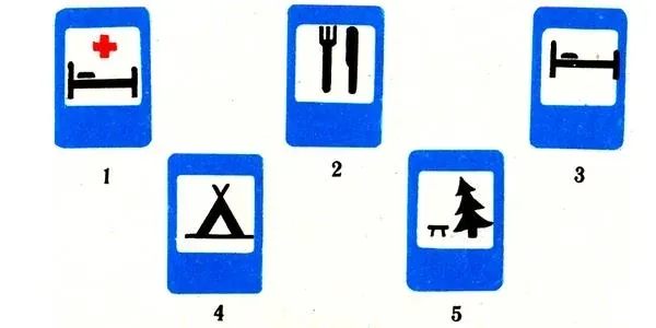
- 1
- 2
- 3
- 4
- 5
Show answer
Correct: 3. 3
“Hotel or motel” is sign 7.9 of the service-signs group, showing a bed — number 3. The others are different service signs: number 1 is 7.2 “Hospital” (a bed with a cross), number 2 is 7.7 “Food point”, number 4 is 7.10 “Camping” (a tent) and number 5 is 7.11 “Rest area”, none of which denotes a hotel or motel. Sign 3 is therefore correct.
Question 40. This road sign indicates:
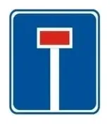
- A road without a through passage.
- The direction of travel towards an object located in a built-up area.
- The end of the deceleration lane or of an additional lane on an upgrade.
Show answer
Correct: 1. A road without a through passage.
The blue square carries a white post crossed by a red bar: that is sign 6.8.1 to 6.8.3 “Dead end”, which the Rules define as a road with no through passage. “A road without a through passage.” is therefore correct. The sign does not show the direction of travel towards an object in a built-up area - route and direction information is given by the advance and direction indicator signs 6.9, 6.10 and 6.12, not by a picture of a blocked road. Nor does it mark the end of a deceleration lane or of an additional lane on an upgrade: those are shown by the lane-configuration signs, while 6.8 describes the road itself, which has no way out.
Question 53. What do the indicated road signs show?
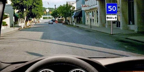
- In the zone of effect of the plate, drivers must travel at a speed higher than that shown on the sign.
- In the zone of effect of the plate, drivers are recommended to travel at the speed shown on the sign.
Show answer
Correct: 2. In the zone of effect of the plate, drivers are recommended to travel at the speed shown on the sign.
The blue square carrying 50 is sign 6.2 “Recommended speed”, the speed preferred for travelling on that stretch of road, and the plate beneath it - 8.2.1 “Zone of action” - shows that the recommendation holds over a section 800 m long. Because 6.2 is advisory only, the correct answer is that in the plate’s zone of action drivers are recommended to travel at the speed shown on the sign. “Drivers must travel at a speed higher than that shown on the sign.” is wrong: a compulsory MINIMUM speed is set by mandatory sign 4.6 “Minimum speed limit”, not by the blue 6.2 square, which obliges nothing.
Question 55. How must the driver act in the given situation?
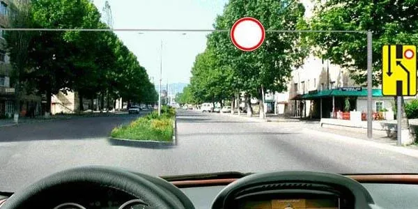
- Continue straight ahead.
- Change lanes into the oncoming traffic lane of the road.
Show answer
Correct: 2. Change lanes into the oncoming traffic lane of the road.
On this road with a dividing strip the driver’s own carriageway is closed ahead: the sign 3.2 “No traffic” hanging over it prohibits the movement of all vehicles, so carrying straight on is not possible. The yellow sign on the right is 6.19.1 “Advance indicator of changing lanes to another carriageway”, which under the road-signs annex shows the way round a closed section of one carriageway on a road with a dividing strip - here across to the oncoming carriageway. The driver must therefore change lanes into the oncoming carriageway of the road.
Question 67. What does the following road sign indicate?
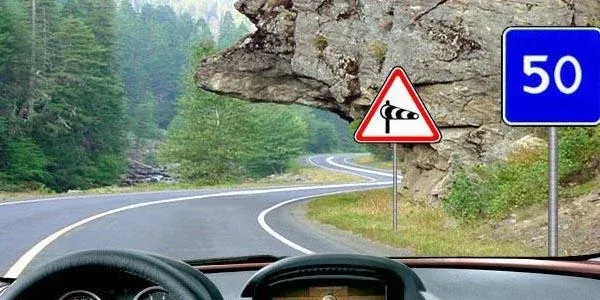
- On this section of road it permits driving at a speed of no more than 50 km/h.
- On this section of road it is recommended to drive at a speed of 50 km/h.
- It is permitted to drive only at the speed indicated on the sign or higher.
Show answer
Correct: 2. On this section of road it is recommended to drive at a speed of 50 km/h.
The blue square carrying 50 is sign 6.2 “Recommended speed”, which the Rules define as the speed preferred for travelling on that stretch of road; here it stands beside warning sign 1.29 “Side wind”, so its zone of action is the length of that dangerous stretch. Because the sign is advisory only, the correct answer is that it is recommended to drive at 50 km/h on this section. It does not mean “no more than 50 km/h” - a maximum is imposed by the red-bordered sign 3.24, not by a blue square. Nor does it mean the indicated speed or higher - a compulsory minimum is sign 4.6, while 6.2 compels nothing and merely recommends 50 km/h.
Question 69. What do the following road signs indicate?
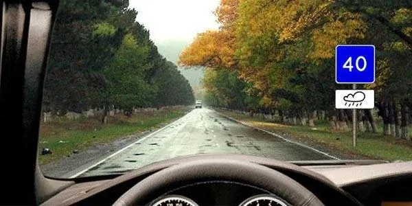
- On a wet road surface it is recommended to drive at a speed of 40 km/h.
- On a wet road surface it is permitted to drive at a speed of no more than 40 km/h.
Show answer
Correct: 1. On a wet road surface it is recommended to drive at a speed of 40 km/h.
The blue square with “40” is sign 6.2 “Recommended speed” (the speed preferred for travel on that section of road), and the plate beneath it showing rain is 8.16 “Wet surface”, which limits the sign’s effect to the period when the carriageway surface is wet. Taken together, the correct answer is “On a wet road surface it is recommended to drive at a speed of 40 km/h”. The other option — no more than 40 km/h on a wet surface — is wrong, because a maximum limit is imposed by sign 3.24 with the red border; the blue 6.2 square only recommends a preferred speed and never sets a binding limit, even with plate 8.16.
Question 691. In which direction is the truck’s travel permitted?
- Only to the right.
- To the right, to the left and in the opposite direction.
- Only to the left.
Show answer
Correct: 2. To the right, to the left and in the opposite direction.
On the far side of the intersection, on the road continuing straight ahead, stands sign 3.4 “Movement of lorries prohibited”, which bars the lorry from that direction ALONE. The blue rectangular sign is one of the information signs 6.15.1 to 6.15.3 “Direction of movement for lorries”, its arrow pointing right; under the catalogue it shows only the RECOMMENDED direction for lorries where their movement in some direction at the intersection is prohibited, and it is not binding. The lorry may therefore travel to the right, to the left and in the opposite direction, and only straight ahead is prohibited. “Only to the right.” is wrong because sign 6.15 does not compel, and “Only to the left.” restricts the permitted directions for no reason.
Question 910. What does the road sign indicate?
- After 500 metres there is a fallen tree
- After 500 metres there is a rest area.
- There is a rest area over a 500-metre stretch.
Show answer
Correct: 2. After 500 metres there is a rest area.
The table and conifer on the blue rectangular panel make this service sign 7.11 “Rest area”, and the 500 m beneath it is plate 8.1.1 “Distance to the object”, which gives the distance in the direction of travel from the sign to the object ahead. The sign therefore tells the driver that after 500 metres there is a rest area. “After 500 metres there is a fallen tree” is wrong because this is a blue SERVICE sign and not a warning of danger, and “There is a rest area over a 500-metre stretch.” misreads plate 8.1.1, which gives the distance TO the object, not the length of a section.
Question 1048. Along which path is it permitted to continue driving?
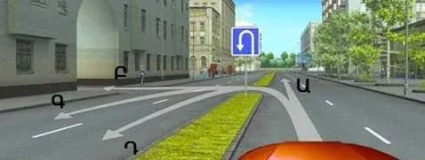
- Only Ա (A)
- Only Ա (A) or Գ (C)
- Only Ա (A) or Դ (D)
- Any, except Բ (B)
Show answer
Correct: 4. Any, except Բ (B)
The blue square sign at the intersection is 6.3.1 “Place for turning”, of which the Rules say expressly that the left turn is prohibited. This sign marks a place provided precisely for turning round, so the U-turn - trajectory Դ (D) - is permitted, as are the straight and right directions; only the left turn, trajectory Բ (B), is prohibited. Travel may therefore continue along any trajectory except Բ (B). “Only Ա (A)” is far too narrow, “Only Ա (A) or Գ (C)” wrongly excludes the very U-turn the sign exists to permit, and “Only Ա (A) or Դ (D)” leaves out Գ (C), which is not a left turn and is not prohibited by 6.3.1.
Question 1063. In which case is the length of the zone for the U-turn indicated?
- Ա (A)
- Only Բ (B)
- Ա (A) and Բ (B)
Show answer
Correct: 2. Only Բ (B)
In case Ա (A) the blue square with the U-turn arrow is sign 6.3.1 “Place for turning”, and the separate 50 m plate beneath it is 8.1.1 “Distance to the object”: that 50 m is the distance from the sign to the turning place, not the length of a turning zone. In case Բ (B) the figure 15 m is printed INSIDE the sign itself - that is sign 6.3.2 “Turning zone”, which the Rules define precisely as the LENGTH of the zone provided for turning. The length of the zone for the U-turn is therefore indicated only in case Բ (B); “Ա (A)” and “Ա (A) and Բ (B)” are wrong because in Ա (A) plate 8.1.1 gives the distance to the place, not the length of a zone.